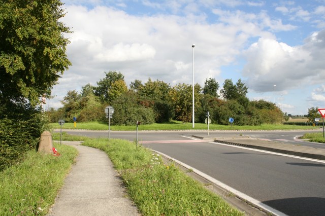
Nineteen of these Demarcation Stones still exist across Belgium, originally erected in the 1920s to either mark the extent of the last German offensive that finally petered out in July 1918, or the point of departure from which the Allies launched their final, successful, onslaught against the Germans in August, depending on which point of view you prefer to take. Perhaps the most famous is this one at the roundabout that was once the crossroads known as Hellfire Corner. Note the sign to the right of the road showing that we are just leaving the outskirts of Ieper.
The stone stands beside the Menin Road just west of the roundabout. Not quite in its original position, due to road widening, but near enough,
Each stone is one metre high, topped with a laurel wreath and a British, as in this case, French, or Belgian helmet, depending on which troops were holding the line at the point where each stone was later erected.
A British gas mask case adorns one of the sides (above), with a water bottle on the opposite side (below).
All the stones have four exploding grenades carved at each corner, and all have the name of the town or city being defended/attacked inscribed on the laurel wreath. The six stones, including this one, that still exist between Boezinge, to the north of Ieper, and Voormezele, to the south, are all inscribed ‘Ypres’.
Originally three sides of the stones bore the same inscription in French, Flemish and English respectively; “Ici fut repoussé l’envahisseur” or “Ici fut arrete l’envahisseur”, “Hier werd de overweldiger tot staangebracht”, and “Here the invader was brought to a standstill”, but in later years many, although by no means all, of these inscriptions have been removed.
Not far from the demarcation stone,…
…there’s a British bunker by the side of the road,…
…but it’s not an easy place to stop, so these shots were taken from the car as we flashed past.


hello magicfingures, just a short note to say thank you for your many interesting postings. I have found a long lost cousin the daughter of an uncle who joined the Scottish Rifles Stephen McQuillin in about 1907, he became a sharpshooter winning various trophies and was the brother of an aunt who was shot by a frustrated cousin who then shot himself. Very sad family history. This happened in Lambeth in 1901, my mother was in the room when it happened aged 11. The swain had been turned down from joining the South African Constabulary and some how acquired a revolver. Nothing changes. How do you manage to achieve such good clear shots?…..Kind regards…..Bill
Thanks for your comments Bill. Much appreciated. A sad, although interesting, story you tell indeed. Oh, and to answer your question, luck, my friend, luck. And a decent eye.
Most of the inscription on demarcation stones were removed (carved out) by or on orders of the Germans in WW II
That’s interesting, because I’ve never been sure exactly when it happened. I do comment on it further if you look at the Potijze Demarcation Stone post (again, use common sense and the Categories links). But I have always rather assumed that it was later than WWII; as we are reasonably sure that the Germans ‘destroyed’ three in Belgium (dredge a few canals – you’ll find them!!) and that they…… hang on, you’ve only just arrived here and I’m starting on one!! Ha! Check out the post I mentioned, see what you think. And welcome again. Btw, quite a few more Demarcation stones coming up soon(ish), if that kind of thing interests you.
What absolutely fascinating detail. Thank you. I’ve traveled these roads and my great grandpa, a major in the Rfa, fought there. I never realised the complexity of the stones or why they were engraved differently. Now I know! I also travelled to hill 60 and hill 62 on the same trip. Such a sad sad history.
Hello Benjamin. Many thanks for commenting. There’s still some contention as to whether the Demarcation Stones mark the end of the German advance in the spring of 1918, or the start of the Allied advance a few months later, but I don’t suppose it matters too much. And of course most were hidden during the Second World War, for obvious reasons, and weren’t necessarily replaced in the right place. I recently wrote about one that I know has been moved three times in recent years: https://thebignote.com/2021/02/26/mont-kemmel-part-one-vierstraat-kemmel-demarcation-stone-no-2/
Otherwise, do explore the Categories List on the right of every page – you’ll find loads more under The Menin Road, including Hill 62, and a separate category for Hill 60. You might enjoy the read. Thanks again for your kind words.